Back Maria Pia-brug Afrikaans Pont de Maria Pia Catalan پردی ماریا پیا CKB Ponte de D. Maria Pia Czech Ponte Maria Pia German Ponto Maria Pia Esperanto Puente María Pía Spanish Pont Maria Pia French Ponte Maria Pia Italian マリア・ピア橋 Japanese
Maria Pia Bridge Ponte D. Maria Pia | |
|---|---|
 Maria Pia Bridge, Porto, Portugal | |
| Coordinates | 41°08′23″N 8°35′50″W / 41.13972°N 8.59722°W |
| Carries | No longer in use |
| Crosses | River Douro |
| Locale | Porto/Vila Nova de Gaia, Portugal |
| Heritage status | National Monument Monumento Nacional Decree 28/82, Diário da República, Série 1, 47, 26 February 1982 |
| Characteristics | |
| Material | Wrought iron |
| Total length | 353 metres (1,158 ft) |
| Height | 60 metres (200 ft) |
| Longest span | 160m (525 ft) |
| History | |
| Engineering design by | Gustave Eiffel Théophile Seyrig Manuel Afonso Espergueira Pedro Inácio Lopes |
| Constructed by | Eiffel & Cª. de Paris |
| Construction start | 5 January 1876 |
| Construction end | 1 October 1877 |
| Inaugurated | 4 November 1877 |
| Closed | 1991 |
| Location | |
 | |
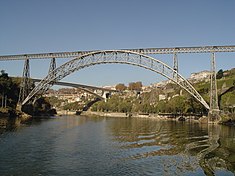
Maria Pia Bridge (in Portuguese Ponte de D. Maria Pia, commonly known as Ponte de Dona Maria Pia) is a railway bridge built in 1877 and attributed to Gustave Eiffel. It is situated between the Portuguese Northern municipalities of Porto and Vila Nova de Gaia.
The double-hinged, crescent arch bridge is made of wrought iron and spans 353 m (1,158 ft), 60 m (200 ft) over the Douro River. It is part of the Linha Norte system of the national railway. At the time of its construction, it was the longest single-arch span in the world. It is no longer used for rail transport, having been replaced by Ponte de São João (or St. John's Bridge) in 1991. It is often confused with the similar D. Luís Bridge, which was built nine years later and is located 1 kilometre (0.62 mi) to the west, although the D. Luis Bridge has two decks instead of one.